Discovering Sanchore District: A Comprehensive Overview
Sanchore district, a recent addition to Rajasthan's administrative map, has gained recognition following the approval of the state government's notification.
 admin
admin
In this article, we embark on a detailed exploration of the newly established Sanchore district, which has emerged as a distinct entity from Jalore district. We delve into a range of vital information, including the district's geographical attributes, administrative divisions, and unique features that make Sanchore stand out.
Introduction to Sanchore District
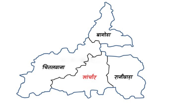
Sanchore district, a recent addition to Rajasthan's administrative map, has gained recognition following the approval of the state government's notification. This new district has been carved out by separating four subdivisions and four tehsils – Sanchore, Chitalwana, Ranivada, and Bagoda – from Jalore district. It's worth noting that this reorganization does not involve any part of the neighboring Barmer district. The emergence of Sanchore as a separate district is the outcome of a bifurcation from Jalore.
Geographical Insights
- Location and Borders: Sanchore district is strategically positioned in the northwest region of Rajasthan. It shares its borders with Jalore, Sirohi, Balotra, and Barmer districts. Moreover, the district also shares an interstate boundary with the state of Gujarat.
Key District Details
The table below provides an overview of essential district details:
| Parameter | Information |
|---|---|
| District Name | Sanchore |
| State | Rajasthan |
| Division | Pali |
| Area | 4500 sq km |
| Population (2011) | 1 million |
| Language | Rajasthani, Hindi |
| Pincode | 343041 |
| Revenue Village | 459 |
Administrative Structure
Sanchore district's administrative framework includes:
- Subdivisions and Tehsils: The district comprises four subdivisions and an equal number of tehsils:
- Bagoda
- Chitalwana
- Sanchore
- Raniwada
Frequently Asked Questions (FAQ)
-
Recognition Date: Sanchore district's recognition was established on 7th August 2023, a date that will be celebrated as the district's foundation day.
-
Tehsil Count: The district features four tehsils and subdivisions, namely Bagoda, Chitalwana, Sanchore, and Raniwada.
-
Distance to Jalore: Sanchore is located approximately 134 km away from Jalore.
-
District Collector: The inaugural District Collector of Sanchore district is Pooja Kumari Partha.
-
Foundation Day Celebration: The notification for the creation of all new districts, including Sanchore, was released on 6th August 2023. The district's foundation day celebration occurred on 7th August.
-
Pin Code: Sanchore district's pin code is 343041.
-
Population Estimate: Sanchore's population is estimated to be around 10 lakhs.
-
District Boundary: Details regarding the specific district boundary are currently unavailable.
-
Notification Date: The notification for the establishment of Sanchore district was issued on 6th August 2023.
-
Village Count: Sanchore district encompasses 459 villages.
As we wrap up our exploration of Sanchore district, it is evident that this newly formed administrative unit boasts a unique blend of history, culture, and geographical significance. With its strategic location and diverse attributes, Sanchore district is poised to carve a distinct identity and contribute to the social and economic fabric of Rajasthan.

.jpg)


.jpg)

